 |
 |
|
|
 |
 |
 |
 |
 |
On December 4, 2000, NASA announced that layered, sedimentary deposits have been identified by the MGS at northeastern rim of Hellas Basin, the chasms of the Valles Marineris, within impact craters of Western Arabia Terra, and the inter-crater plains of northern Terra Meridiani. These new findings support theories for the presence of large amounts of liquid water on the surface of Mars for the millions of years necessary to create these deposits. Given that life emerged on Earth almost immediately after the Hadean era (a 200-300 million year period of massive bombardment approx 4 billion years ago), it would seem that life, at least simple life, is an ubiquitous process in the universe. Thus, the chancethat Mars too, had life at some point in its past has just dramatically increased. Return to Mars topo map.
Aside: Something else to think about: It would seem, prior to the putative arrival of Mars Polar Lander wreckage on the south pole, that the Americans and the Soviets, like medieval popes and monarchs before them, had divided an entire world amongst themselves into two hemispheres of exploration. For all the American landers prior to now have touched down in the northern hemisphere, all the Soviet ones in the southern. Granted the data set on which this speculation is based is rather small.
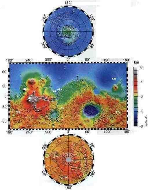
In late May 1999, NASA's Jet Propulsion Lab released the impressive mapping results from Mars Global Surveyor to the press, coincident with the publication of an article in Science. I have modified JPL's false-color topographic map to reflect a more intuitive layout (IMHO; granted the former layout was more compact). The false color scale off to the left shows the corresponding elevation. The datum, defined as 0 km, is light yellow-green. According to the most recent results from MGS, there was probably an ancient northern ocean corresponding to the medium/dark blue contour, fed by channels off Tharsis and from Valles Marineris coursing thru Chryse.
The prime meridian runs straight down the center of all three sections of the map. (It would seem that the cartographers selected tiny Crater Airy, 5 degrees south of the equator in the middle of Sinus Meridiani for Ground Zero. Well, everyone has to start somewhere. Perhaps a descendant of Lord Airy's sat on the naming committee. According to Spaceflight Now, the prime meridian was first defined by the German astronomers W. Beer and J. H. Madler in 1830-32.) The equator runs from left to right across the rectangular portion, which extends to the 70th parallels north and south. It is over 21,300 km wide at the equator; but only about one third that, 7300 km, at the 70th parallels due to the unavoidable distortion when rendering a spherical map onto a flat surface. Imagine curling the central part into a ring so the left and right edges meet. Then fold over the two ends, capping the tube so all the coordinates line up. Topologically, you have a cylinder masquerading as a sphere. Each tick mark on the scale around the rectangular portion equals 5 degrees latitude or longitude. Note how the latitudinal ticks stretch farther from the equator to compensate for distortion.
Meanwhile, the north and south polar projections also extend to the 70th parallels. The top and bottom circular sections have a diameter of 2400 km. The gray circle at the south pole is an image artifact.Return to Mars topo map.
For reference, the Martian moon Phobos is in a 5836 km × 6117 km × 1.1 ° orbit, while the other moon Deimos is in a 20108 km × 20146 km × 2 ° orbit.
Here are some features which I found noteworthy:
Analysis
The revised description of the Hellas impact basin in the Southern Hemisphere impelled me to do some of those back o' the envelope calculations which I so dearly love.
Assuming as a first approximation that the thickness of the debris falls off linearly with distance (in fact it falls off more steeply than that, parabolically), then the total volume of the ejecta can be approximated by an annular cone 2 km high x 4000 km radius with a hole of 1050 km radius.
Vol = (pi* (Ro2 - Ri2) * t)/3 = 32 million km3 (roughly).
Conclusion? It was reasonable for NASA to say that Hellas ejecta from the Hellas Impact is an important component of the overall topography of the Martian Southern Highlands.
Ain't physics fun? Return to Mars topo map.
*According to a recent lecture given at NASA's Goddard Space Flight Center, planets tend to form first crusts predominantly in one hemisphere. Mars is frozen with most of the high lands in the southern hemisphere and a great basin in the northern hemisphere. This is probably the original configuration although the poles may have drifted.
The Earth also shows this property with most of the continental crust now in the Northern hemisphere and this polar distribution being much more common through geologic history than a uniform distribution.
Why crusts would tend to form on one side only isn't clear: early in geologic history, a planet's rotation rate is relatively rapid and it has a dense atmosphere due to volcanic outgassing. These factors would tend to iron out differences in insolation and emissivity of various sorts of magma. Do plates tend to congregate?Return to Mars topo map.
NASA said that Hellas basin is 2100 km diameter and 9 km deep. (The entire state of Alaska could be dropped into it with lots of room to spare; the summit of Mt. Denali would still be ~3 km below the crater rim.) NASA also reported that the ejecta blanket is 2 km thick at the crater's rim, and extends out 4000 km from ground zero. (By comparison, the most recent printed map, available from the Planetary Society, which was based on Viking and Mariner data, says Hellas is 5-6 km deep at most.) This is also at least twice the depth as described in Kim Stanley Robinson's Red/Green/Blue Mars trilogy.
Now the crater can be approximated by a very low cylinder (think of the proportions of a dime - American ten-cent coin) because the thickness of the ejecta layer which fell back inside the crater is at least as thick as the ejecta layer at the rim. Thus it's volume is
Vol = (pi * R2 * h) = 31 million km3(roughly), within 3% of the first figure.
Scaling from Chixulub crater on Earth (site of the K-T impact which killed off the dinosaurs), and allowing for Mar's shallower gravity well and lighter material, I estimate that the Hellas impactor was at least 140 km in diameter.
For product or dealer inquiries within the USA & Canada, call:
Outside USA: +1 (865) 483-7097 -- note area code has changed from (423)
or send us a fax: +1 (865) 483-6317 -- note area code has changed from (423)
or write to us:
The Ultimax Group, Inc.
112 Mason Lane
Oak Ridge, Tennessee, USA 37830-8631
The entire content (images and text) of these pages is copyrighted and may not be distributed, downloaded, modified, reused, re-posted or otherwise used without the express written permission of the authors.
Privacy Policy: The Ultimax Group Inc., will never sell our customer list or distribute our customer's personal data to others without permission.
These pages last updated April 1, 2003